
This post takes a little journey to get to the point…but we think it’s worth the trip, and it should help demonstrate the power of old property records. In case you missed it, we’re building off of last week’s review of DeedMapper (Product Review: DeedMapper 4.2 – An essential tool to bring land purchases/sales into your Family History research)
Deed Books are a great tool to move forward some of your most stubborn research questions, and there is a great deal of data in them, but without a tool like DeedMapper you’re likely not going to get the full picture of what’s found in them!
On Michael’s paternal line, the Tradewell’s are one of the two brickwalls left on that side of the tree…which is all the more ironic because the matriarch of family history research on that line was Myra (Tradewell) Morse (1870-1962). In all of her genealogy notes, and DAR applications, and family history presentations she never recorded the name of her Great Grandfather…and thus we have a brick wall.
About a year and a half ago we wrote about discovering formal genealogical “Research Reports” (Elizabeth Shown Mills has just the right guidance at just the right time!) and started drafting them for our toughest cases. Of course, the Tradewell line was the first subject. We knew that James B Tradewell is our 4x GGF and that he arrived in Racine County, Wisconsin Territory ca. 1844, where he and his wife Catherine lived until their deaths. We also knew that there was an Ephraim Tradewell, and his wife Marina, also arrived in Racine County around 1844, and that both men listed New York as their birth location. A little research showed that there were a James B and Ephraim Tradewell in Schoharie County, New York for the 1820, 1830, and 1840 U.S. Census but each disappeared after that and no further records were found for them there.
We wrote an “Analysis and Research Plan” for them, and it laid out the following questions we’d hoped to answer:
- Were the James B and Ephraim Tradewell in Wisconsin from after 1844 the same men as those listed in the 1820-1840 U.S. Census in Schoharie County, New York?
- Were they related, and/or did they even know each other?
- Who was each of their fathers, and was either of those persons the brickwall 5x GGF?
Reviewing the Schoharie County Deed Books for 1797-1850 gave us some of the answers, and DeedMapper filled in a major piece of the puzzle.
Were the Wisconsin Tradewells the same as the New York Tradewells?
The answer is now a proven yes! Deeds were usually recorded with the Husband as the only purchaser, but almost always the wife is listed when a property is sold. In fact, every Deed we reviewed where we know we had an ancestor selling property, the wife isn’t just listed, there’s a statement from the County Clerk that recorded the deed that the wife was taken aside out of the presence of her husband to confirm she was willingly agreeing to the transaction. Besides making us wonder if any wife EVER felt empowered enough to say “no”, several sales gave us the names of the New York Tradewell’s wives: James B Tradewell was married to Catherine (Edwards) Tradewell, and Ephraim was married to Marina Tradewell. A perfect match!
We also saw a clean break in New York, with the last Tradewell land transaction completed in the summer of 1842, and the first Wisconsin transaction being conducted in 1844.
Were James and Ephraim related, and/or did they even know each other?
We still do not know if they were related, but we know they were likely very close and in fact lived next to each other…and we never would have known that without DeedMaker. Just reviewing the Deed Books, we learned that they were involved in one land transaction that indicates they were likely in a close relationship. On 7 April 1838 James sold Lot #7 of “Tradewell’s Tavern Stand” in Gilboa, NY to Ephraim for $200. Two weeks later, on 21 April 1838 Ephraim sold the same property to Sidney Tuttle for $200. We’re not sure exactly what was going on there, but it’s very likely there was coordination between the men for this to occur.
But what really sold us on DeedMapper, was what happened when we mapped all the plots we discovered in the 1797-1845 Deed Books. The biggest breakthrough came when we first mapped two properties, with no common points in their Legal Description, and they clearly fit together. Without sharing Metes & Bounds points in the description (like a Willow Tree), there’s no easy way to determine how they relate, but when you map them visually you can see them like jigsaw puzzle pieces and get a great feeling of location for the land.
Once we had those two properties mapped (both were owned by James B Tradewell and recorded in 1806), we drew another plot owned by Ephraim (recorded 1834) and we immediately knew they lived together as neighbors with an adjoining property line.
Here is the first Legal Description for James’ largest plot:
Beginning at a Willow tree near the Schoharie Creek marked on the east side with the Letters C.E. and runs thence south 15 degrees east 10 chains and 60 links, thence East 25 chains, thence north 21 degrees 30 minutes east 32 Chains, thence north 10 chains 50 links, thence west 17 chains and 50 links to the Schoharie creek, thence along said creek to the place of beginning containing 117 acres of land be the same more or less.
And here is the Legal Description for Ephraim’s plot:
Beginning at a hemlock sapling on the East side of Schoharie Creek marked on 4 sides with 3 notches and a blaze on the North side B.H, on the South side I.D. and runs thence North 30 degrees East 8 chains, thence, North 24 degrees West 12 chains, thence, due West 25 chains, thence, North 15 West 10 chains 60 links, thence, South 41 degrees West 12 chains to the west side of said creek, thence, South 2 degrees West 5 chains 75 links, hence, North 52 degrees East 2 chains, thence South 62 degrees East 6 chains to the North East side of said creek, thence, up said creek to the place of beginning.
These two plots, recorded almost 30 years apart, and showing no common marker other than Schoharie Creek, when drawn, revealed just how closely these men lived:
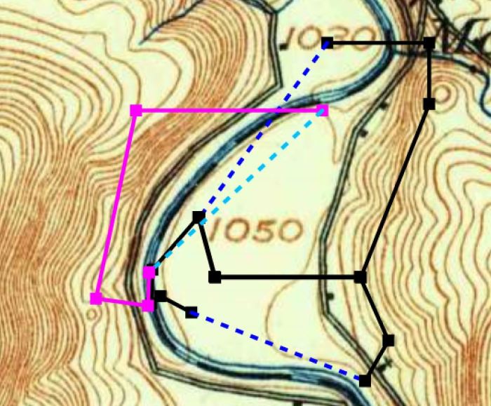
The beauty of DeedMapper is that this is first time we worked with Metes & Bounds land descriptions, the first time we’d recorded large amounts of deed information, and this was the 3rd time we’d ever entered information into the software. We literally knew almost nothing about what we were doing, and DeedMapper brought home how closely these men lived.
Now, it doesn’t prove James and Ephraim were related, and it’s likely only DNA will ever do that, but there is now no question these men had a close relationship. They weren’t distant cousins that lived miles apart in the same County, their families lived right next to each other.
Who was their father?
We still don’t know. This creek that’s referenced in so many of the deeds was dammed up in the 1920’s to provide drinking water to New York City, and all of this land is under a reservoir. However, that project caused the local Gilboa cemetery to be relocated, which gave us strong evidence that our 5x GGP were Reuben and Esther Tradewell, and if we can ever prove that James and Ephraim were brothers, we’ll then likely know Ephraim’s father too.
So, Deed Books are a great tool to move forward some of your most stubborn research questions, and there is a great deal of data in them, but without a tool like DeedMapper you’re likely not going to get the full picture of what’s found in them!

 The next thing we wanted to do was see this on a map, and while DeedMapper has many local maps for purchase, they suggested we download free USGS Topographical maps instead…which worked perfectly because the Schoharie Creek was dammed up in the late 1920’s and no longer runs where any of these property descriptions ran 100 years earlier. The USGS Topo map we downloaded was from 1903, so we were able to get much closer to where the creek ran in 1806.